Incorporate This Golf Invention Into a Smart Phone App and I Would Lower My Handicap Quickly
I fairly consistently hit my putts where I intend; the problem is that where I intend to hit them rarely correlates with where the hole is actually located for putts of ten feet or more. This is probably true for most golfers that have handicaps over five. Therefore, the following recently issued patent really caught my eye (although some of the language in the claims strikes me as odd).
The patent is USPN 7,713,148 titled “Topography Linked Golf Aid,” which describes the invention as:
The patent goes on to explain:
Dave Dawsey - Monitoring Green Reading Inventions
The patent is USPN 7,713,148 titled “Topography Linked Golf Aid,” which describes the invention as:
A method, apparatus, and program for computing a path, starting velocity, aim angle, and aim points for directing a putted golf ball from a point on a golf course to another point and incorporating such data into easily read charts or electronic media is provided. The invention also provides a means of determining the initial launch conditions and actual path a putted golf ball traveled on given its starting and ending ball positions.
The patent goes on to explain:
Great invention, but I just don’t understand why it needs a video component versus a static image showing the contour and proposed path of the putt (although it appears to have been a limitation required by the patent office).Broadly speaking, the invention provides a method, apparatus, and program for computing a path, starting velocity, aim angle, and aim points for directing a putted golf ball from a point on a golf course to another point (any arbitrary location, including but not limited to the hole) and incorporating such data into easily read charts or electronic media. The invention also provides a means of determining the initial launch conditions and actual path a putted golf ball traveled on given it's starting and ending ball positions.
The invention can be implemented in numerous ways, including as a system (including a computer processing system), a method (including a computerized method), an apparatus, a computer readable medium, a computer program product, or a data structure tangibly fixed in a computer readable memory. Several embodiments of the invention are discussed below.
As a method, an embodiment of the invention includes surveying the topography of a golf hole, converting surveyed topography data into a 3-dimensional surface model, computing a path trajectory, an aim angle, and an initial velocity for the desired putt, calculating, from the aim angle, an aim point distance to the right or left of a target that the golfer should aim towards, further calculating a break point of the putt trajectory, and displaying suggested aiming and stroke information. The method may further include incorporating a set of aim point distances into graphical charts or electronic media so that aim points and stroke data for possible combinations of target and ball positions may be displayed.
The method of the present invention may be implemented as a computer program product with a computer-readable medium having code thereon. The program product includes a program and a signal bearing media bearing the program. As a computer system, an embodiment of the invention includes code devices executed by a processor of a computer system for receiving topographic information, current ball position information, target information, such as the location of the cup or any arbitrary end point, and computing and displaying aim points, path, and stroke information. The code devices execute the methods of the invention. As an apparatus, the present invention may include at least one processor, a memory coupled to the processor, and a program residing in the memory which implements the methods of the present invention. As a computer readable medium containing program instructions for receiving topographic information, current ball position-information, target information, and computing and displaying aim points, path, and stroke information. The invention may also be implemented as computer executable software code transmitted as an information signal, the code performing the methods of the invention.
Specifically, an embodiment of the invention includes a method of providing putting information comprising: (1) receiving a start position of a golf ball relative to the putting green; (2) receiving a desired target location relative to the putting green; and (3) calculating a putting parameter for propelling the golf ball from the start position to the target location based on a trajectory corresponding to a desired capture velocity of the ball, wherein the trajectory has a start point substantially corresponding to the start position and an end point substantially corresponding to the target location. The putting parameter comprises an aim angle, an initial velocity, and an aim point distance (and direction) relative to the target location based on the aim angle. Indicia indicative of the putting parameters are displayed for the user. The indicia comprise an aim point icon and an initial velocity icon. The method further includes receiving the desired capture velocity of the ball, wherein capture velocity is the velocity at which the ball passes through the target location including, but not limited to, being captured in the hole. Other parameters may include a green speed parameter and grain.
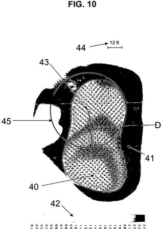
In a further embodiment of the invention, the method includes receiving topography information corresponding to a putting green; and converting the topography information into a three dimensional surface model for determining a plurality of trajectories, each trajectory corresponding to a plurality of capture velocities of the ball. The trajectories are determined by computing gradients between adjacent points of the three dimensional surface model along each trajectory; and predicting a motion of a simulated golf ball moving between the points along the trajectory based on the respective gradients between the adjacent points; a coefficient of rolling friction of the ball, and an initial condition of the ball. In an embodiment, the initial condition comprises a directional velocity of the ball. Indicia indicative of a slope direction and slope magnitude of a portion of the putting green are displayed to the user or provided as part of a putting aid. The difficulty of an attempt to propel the golf ball from the position to the target location may also be provided.
In a further embodiment, the plurality of trajectories is determined for substantially every grid point on the green. These trajectories are stored for later reference. The putting parameter is calculated by selecting optimal values from the grid points on the green closest to the position of a golf ball. Optionally, the putting parameter is calculated by selecting and averaging optimal values from the grid points on the green closest to the position of a golf ball. The putting parameter may also be calculated by selecting optimal values from the grid points on the green closest to the position of a golf ball to use as a basis for calculating the putting parameter for the actual ball coordinate.
The method of the invention further includes calculating an aim point distance relative to the initial break coordinates for the target location based on the aim angle. Moreover, the invention includes outputting audio indicia indicative of the putting parameters.
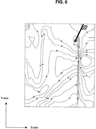
A contour chart may also be used. Specifically, indicia indicative of the putting parameters are displayed with the use of a contour chart. The contour chart utilizes different colors (or other variable indicia) to represent the putting parameters.
The position of a golf ball relative to the putting green may be received by one or more of global positioning (GPS) data, radio frequency data, optical data, or laser data. The position data may also be input by a user.
In an embodiment, the invention includes overlaying on an image stream transmission a visual path trajectory based on calculated putting parameters. Additionally, an image stream transmission may overlay a visual path trajectory representative of an actual path calculated from a known start point substantially corresponding to the position and a known end point substantially corresponding to the target location.
The invention also provides for simulation. Specifically, a putt may be simulated based on a simulated position of a golf ball.
Calculating the putting information includes determining for a plurality of location coordinates on a putting green optimal trajectories corresponding to a desired capture velocity for a golf ball to move from said location coordinate to an end point; and calculating putting parameters to propel a golf ball along a path substantially following the optimal trajectory.
As a computer-implemented simulation program, the invention provides for simulating green break characteristics for a green utilizing software code for receiving a simulated position of a golf ball relative to the putting green; and for calculating a putting parameter for propelling the golf ball from the simulated position to a target location based on a trajectory corresponding to a desired capture velocity of the ball, wherein the trajectory has a start point substantially corresponding to the position and an end point substantially corresponding to the target location.
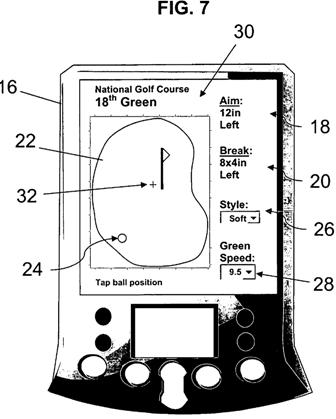
In another embodiment, the invention includes a computing device (such as a hand held device, palm device, or the like) for providing putting information, comprising: input mechanism for receiving a position of a golf ball relative to the putting green and receiving a desired target location relative to the putting green; and a processor for calculating a putting parameter for propelling the golf ball from the position to the target location based on a trajectory corresponding to a desired capture velocity of the ball, wherein the trajectory has a start point substantially corresponding to the position and an end point substantially corresponding to the target location; and an output device such as a display for displaying the putting parameter or audio device for providing the putting parameter. The computing device may also include or have access to storage media for storing a plurality of predetermined trajectories, each trajectory corresponding to a desired capture velocity of the ball.
As computer readable media containing program instructions for providing putting information, the invention includes computer program code for receiving a position of a golf ball relative to the putting green; receiving a desired target location relative to the putting green; and calculating a putting parameter for propelling the golf ball from the position to the target location based on a trajectory corresponding to a desired capture velocity of the ball, wherein the trajectory has a start point substantially corresponding to the position and an end point substantially corresponding to the target location.
Dave Dawsey - Monitoring Green Reading Inventions


Comments